
Spatial Production Allocation Model
Brief model summary
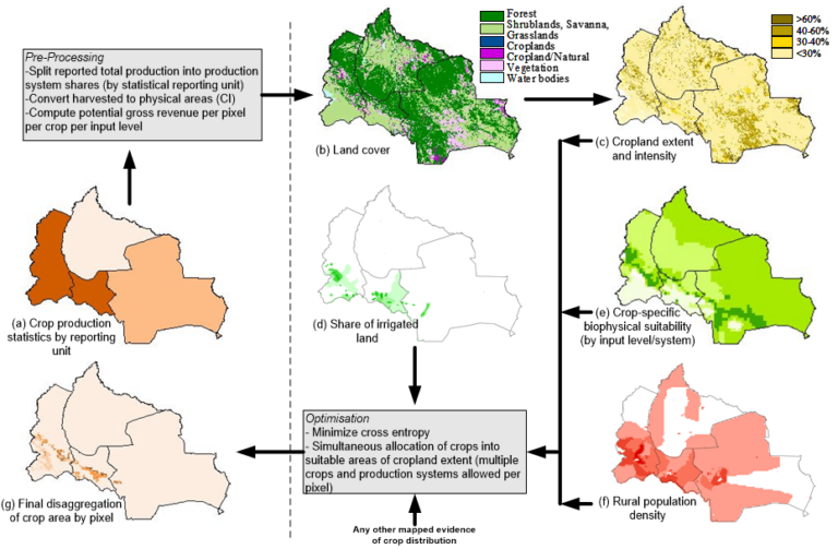
The Spatial Production Allocation Model (SPAM) is a tool developed by IFPRI, aimed at enhancing the understanding of global agricultural production through detailed spatial data. It operates on a cross-entropy approach to generate plausible estimates of crop distribution across various spatial units, transitioning from broader areas like countries and provinces to more refined grid cells. This method uncovers the spatial patterns of crop performance, creating a comprehensive global grids cape that merges geographical data with agricultural production systems. The primary goal of SPAM is to improve spatial insights into crop production systems, enabling policymakers and donors to more effectively target agricultural and rural development policies and investments. This, in turn, aims to boost food security and economic growth while minimizing environmental impacts. The latest version, SPAM 2020 (Beta), along with previous versions (SPAM 2000, SPAM 2005, SPAM 2010, and SPAM 2017-SSA), are available for access and download, supporting a community of users who contribute to its ongoing development.
Input data
The model integrates various inputs, including:
Crop Production Statistics: Sourced from national and sub-national levels, with a focus on developing countries.
Land-Cover Image: Identifies cropland.
Crop-Specific Suitability Information: Based on local landscape, climate, and soil conditions.
Spatially Explicit Data: Includes biophysical crop suitability assessments, population density, and knowledge about specific crops’ spatial distribution.
Output
This methodology provides a detailed and nuanced approach to estimating crop distribution, taking into account a wide range of factors from land suitability to cropping practices and irrigation.
Methodology overview
- 1. We start with the administrative (geopolitical) units for which we have been able to obtain production statistics. These may typically be national or sub-national administrative regions such as countries, states, districts, or counties. The smaller the administrative units, the better the results.
- 2. We receive an already classified land-cover image, where cropland has been identified.
- 3. We integrate crop-specific suitability information based on local landscape, climate and soil conditions, which provides information on how MUCH cropland exists at the pixel level.
- 4. Combining all these input data and some more parameters the model applies a cross-entropy approach to obtain the final estimation of crop distribution.
Software requirements
The SPAM 2020 V0r1 from Aug-31-2023 has been migrated from a FOXPro program to a R-based program environment.
Accessibility
User documentation
Code
Code repository:
Data repository:
Annotated references
Spam list of publications is available from this web page (https://mapspam.info/publications/).
Acknowledgements
Many people and institutes provided data or comments/feedback to SPAM.
In particular we’d like to thank the following people: Ayumi Arai, Carlo Azzarri, Melanie Bacou, Surajit Baruah, Jordan Chamberlin, Maria Comanescu, Cindy Cox, Günther Fischer, Yue Gong, Beliyou Haile, Daniel Hawes, Mario Herrero, Robert Hijmans, Dave Hodson, Glenn Hyman, Shahnila Islam, Andy Jarvis, Nanga Kaye, Amy Kapp, Erwin Kalvelagen, Zahia Khan, Ho Young Kwon, Chris Legg, Gucheng Li, Daniel Mason-D’Croz, Gerald Nelson, An Notenbaet, Navin Ramankutty, Ingrid Rhinehart, Cleo Roberts, Ricky Robertson, Ivy Romero, Cynthia Rossi, Kate Sebastian, Dongsheng Sun, Philip Thornton, H.T. van Velthuizen, Ivan Vidangos, Ojo Williams, Stanley Wood, Wenbin Wu, Hua Xie, Han Xu, Biwen Zhou.
Thank you to HarvestChoice for your support and Hormel Foods for the inspiration of the name.